v3 is innovative efficient practical useful structured direct data also dimensional.

Everything else is just flat.®

Unique Parallax Visualization and Image Analysis Technologies

Patented Technologies

Parallax Visualization extracts and presents the inherent three-dimensional information in motion imagery.

Image data extraction detects, tracks, identifies and databases objects in video/image sequences.

Automated Video Analysis Software

We detect, track, classify, geo-locate and database object information extracted from, among others, streaming video. We do it in real-time. And we do it without requiring a software training database.

artificial-intelligence-01

Unique Capabilities

This is NOT an Artificial Intelligence (AI) or Machine Learning (ML) or Deep Learning (DL) technology.
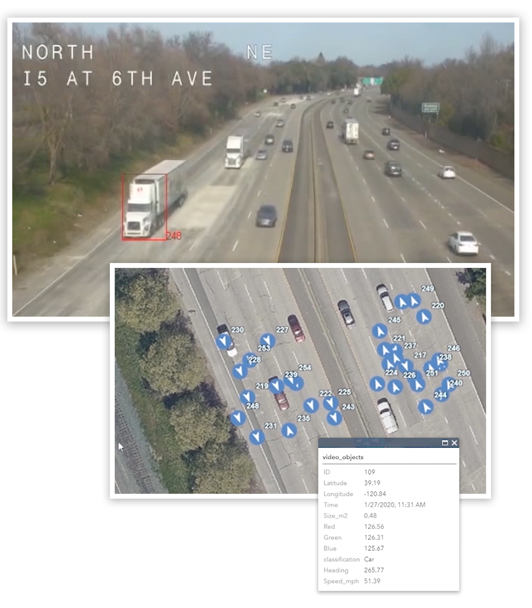
software-icon-01

Mathematical Engine

Our v3 Tools software is powered by proprietary parallax induction and segmentation image analysis algorithms.

graph-01

Video to Data

v3 Tools is a mathematical engine that directly converts video into structured labeled data.

Real-time Conversion of Video into Structured Geo-located Data

The saying goes, “a picture is worth a thousand words,” which is an acknowledgement of how many written words it would take a human to describe an image in detail. And in the case of video multiply that figure by 30 for every second.

v3 Tools automatically dissects each image into its component pieces and writes that information into a structured database without any human intervention.

Software Capabilities

Real-time performance on a single processor

Video output format processing is GPU accelerated
Reads video and images from cameras directly into memory in real-time
Detects moving and stationary targets
Image quality module to enhance video quality prior to processing
Real-time dashboard: waterfall displays of processing quality, number of target detected and tracked, and histogram of track lengths
Automatically generates a Tracking Report
Sends tracking data in real-time to ArcGIS directly or via TCP or JSON socket

v3 Trafficview ™

Trafficview™ is a subset of v3 Tools that is designed to use streaming video or CCTV to count cars, trains and people and send the extracted data to ArcGIS Pro in real-time. Trafficview is a practical tool for reading roadside streaming camera feeds to detect, track, count, measure, classify, geo-locate and database the extracted vehicle information while at the same time sending a real-time TCP and or JSON data socket to ArcGIS Pro for visualization.